 |
|
|
|
| Author |
Topic: Mystery map |
|
alexkeys
|
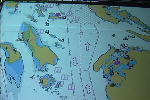
I have this image of a gps map display and am trying to figure out where exactly it is.
I was hoping someone could drop me a note if they recognize the location/area at all.
I think it is from near Victoria... maybe as far as Vancouver or Washington State.
Any thoughts would be helpful.
Thanks
Alex
|
FishWish
|
That's just off Sidney. The island in the middle of the chart is Sidney Island, and the island towards the left with the shallows off the south end is James Island. You can see the shipping lanes marked on the right of the chart and the San Juan Islands are also on the right.
Hope this helps,
FishWish
|


|

Home |
Sign Up |
Contact Us |
Forum |
Forum Policy |
Site Map
Disclaimer: All information on this site, including depth charts,
maps, directions are not intended for navigational use.
Copyright 2003-2024 SharpHooks.com. All rights reserved.
|
|
| SharpHooks
is now FREE!  Login Login - View All Submit New
To submit new report: 1. Select fishing spot from
Trip Planner 2. Submit new report - Buntzen Lake - South
Fishing: Fair
Catch: 1 Pikeminnow
Wed, Mar 20, 2024
- Swalwell Lake - West
Fishing: Moderate
Catch: 5 Rainbow Trout
Sun, Feb 04, 2024
- Francis Lake
Fishing: Fair
Catch: 1 Rainbow Trout
Mon, Nov 13, 2023
- Chehalis - Logging Bridge
Fishing: Unknown
Catch: 0
Fri, Jun 23, 2023
- Devils Lake - Mission
Fishing: Good
Catch: 2 Bass
Wed, Jun 07, 2023
- Hicks Lake
Fishing: Fair
Catch: 2 Rainbow Trout
Sat, Jun 03, 2023
- Elbow Lake
Fishing: Good
Catch: 5 Rainbow Trout
Fri, Jun 02, 2023
- Mill Lake
Fishing: Unknown
Catch: 0
Mon, Feb 27, 2023
| | | |